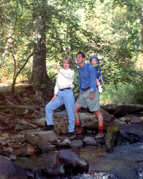
If you’d rather not hike that far and your car (and driver) can handle rough terrain, drive to the top and hike down to the jutting rock overlook. The dirt/gravel Currahee Mountain Road is passable, but travel is slow and dicey near the top. You need to be especially careful choosing your path if your car has a low chassis. Take Hwy. 123 North from Toccoa, turn left onto National Forest Road #62 directly before Ayersville Road at the Milliken plant. Look for a large brown sign that says "Lake Russell Wildlife Management Area, Chattahoochee National Forest". Broad River Trail – This trail is located in the Lake Russell Wildlife Management Area and is maintained by the U.S. Forest Service because it is in the National Forest System of Trails. Don’t hike any trail or road that will take you on Wildlife Management Areas or privately owned land during deer hunting season. You may call the Department of Natural Resources at 770-535-5700 to verify hunting seasons in these areas. Broad River Trail is a camping, hiking, and fishing paradise with an abundance of wildlife. This is a relatively easy hike and is excellent for novice hikers and family groups. The trail follows streams, waterfalls, lush mountain foliage and runs 3.8 miles from Farmers Bottom to where Dicks Creek intersects with Forest Service Road #87. To get there: Take Highway 123 North from Toccoa and turn left onto Ayersville Road at the Milliken Humphrey Plant. Go .8 mi. to Forest Service Road #87 and turn left onto the dirt/gravel road. This service road is rough and rocky in some spots so you need to be careful if you are in a low-chassis car. As you travel 2.1 miles, you’ll pass the Ranger’s checking station on the left. Bear to the left at the fork in the road and drive until you see the brown and beige sign on the right that says "Hiker Trail." Follow the blue blazes. Panther Creek Trail – This trail is in Habersham and Stephens Counties and is under the jurisdiction of the Chattooga Ranger District in Habersham County. It is part of the National Forest System of Trails and is maintained by the U.S. Forest Service. It is a six-mile hike, one way, and is for the sure-footed and those unafraid of heights. For the experienced hiker, the scenery is well worth the effort: cliffs, huge boulders and waterfalls make this stream one of the most scenic areas in Georgia. The starting point in Stephens County is near Yonah Dam. To get there: Follow Prather Bridge Road (Highway 184) until it becomes Yonah Dam Road. After you cross the bridge where Panther Creek meets the Tugalo River before you get to the dam, bear left and take the first dirt road to the left, which is Panther Creek Road. Follow this road until it dead ends. Cross the metal footbridge and take the trail up the hill to the right. To the left is a large grove of walnut trees, growing in rows. The symmetry is an odd juxtaposition to the natural setting.
This trail is considered easy to moderate and is 6.0 miles, one way. Most of the typical mountain streamside plants abound along Panther Creek. Rhododendron, mountain laurel, large white pine, hemlock and beech grow beside the stream. The first 2.0 miles is difficult because it is less defined and more dangerous than the rest of the trail. You’ll come upon a large, enticing pool at the base of a series of waterfalls that has a splashing slide in the middle. Not knowing what to expect, most people are astounded by the beauty, size and power of the waterfall, especially during the high water levels of winter and spring. The steep path goes up the side of the falls to the next protruding vantage point, then goes upward to the outer edge of an immense outcropping and winds along the upper falls. Path-narrowing outcrops past the falls lead to the high shoals near the logged area. For approximately one mile, the path rises and dips, conforming to the creekside topography. The stream becomes calm and the trail is sidewalk flat for a while, then you have to negotiate guy wires, rocks and fallen trees as you walk under the Highway 441 Bridge. Across the road is the Panther Creek Recreation Area, which has restrooms and picnic areas – perfect for a break before you start back to your vehicle. |


 across a power line clearing and makes a steep ascent up the mountain. The forest types are shortleaf pines and mixed hardwoods, such as oak, hickory and sweet gum. As you reach midway, the number of large rock formations increases and trees wrap their roots picturesquely around them. Close to the top is a giant rock overhang that provides a panoramic view of rolling hills and the beginning of the mountain range. Adventurous souls rappel and hang glide from this perch. Birds fly by at eye level. If you carry a daypack, this is a great place to spread out a blanket, have a picnic and relax. Following the trail further up takes you to the fence surrounding the communications towers next to the maintenance building. On the very peak of the mountain is where the old ranger tower used to be. If you follow the dirt/gravel road a few yards down the other side of the mountain, there is a graffiti covered rock that also provides a nice view, but it doesn’t compare with the one at the rock overhang.
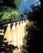 Yonah Dam, completed in 1925, is the lowest step in the staircase of six power developments down which the waters of the Tallulah, Chattooga, and Tugalo rivers are led in their plunge from the Blue Ridge Mountain heights toward the Atlantic Coastal plain. Yonah’s storage lake (approximately 320 acres of surface area and 150,000,000 cubic feet capacity) is impounded by a cyclopean dam 900 feet long and 75 feet high with a direct plunge from surface to waterwheel of 75 feet. It has three 12,500 horsepower waterwheels. Power is developed at a voltage of 6,600 and is stepped up to 110,000 volts for transmission to the 81 cities and towns in the company’s territory. To get there: Follow Prather Bridge Road (Highway 184) until it becomes Yonah Dam Road and follow it out to the dam. Yonah Dam Road is a great place to ride a bicycle. The road is relatively flat and it’s an easy ride next to the Tugalo River. The temperature drops 10 degrees because of the proximity to the flowing river that is fed by Lake Yonah, which in turn is fed by colder mountain lakes and streams. Riding from the picnic area near the dam to Prather Bridge Road, you pass several historic houses.
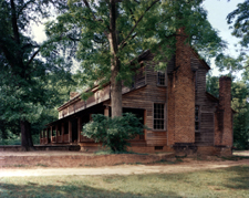 cabins, including an original Stagecoach Inn and a new 5000 square foot Lodge. The cabins were moved and restored by local craftsmen using cedar and chestnut interior designs to create their special beauty and authenticity. The Johns House is a charming Victorian cottage on the right before you get to Prather Bridge Road. Built in 1898, it shows the influence of the era. The trim on the front gable and porch is outstanding. The front door has a fanlight with sidelights. Slender posts with banisters and trim support the porch roof. The present structure was built around a log cabin. Further down on the right, on a hill overlooking the valley of the upper Tugalo River is Riverside. This beautiful twelve columned, Greek revival antebellum home was built in 1850 by James D. Prather with the labor of his slaves and the timber from his plantation. As was usual in those days, the kitchen was separate from the house. The smoke house still stands and is now used as a garage. Ice caves still exist.
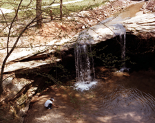 Some of the more popular primitive camping areas open to the public are in the Lake Russell Wildlife Management Area and in the Chattahoochee National Forest. Call the U.S. Forest Service at 770-297-3000 for more information. Toccoa RV Park and Campground (706-886-2654) offers full hook-ups, laundry room, bathrooms, phone hook-ups, and sewer dump stations. There is also a pavilion and nature walk. From Hwy 17 out of Toccoa, turn left on Oak Valley Road and follow the signs. The park is 3.2 miles on the right. Georgia Baptist Conference Center has a 19-site campground complete with water and electrical hookups, a bathhouse and laundry room. Call 706-886-3133.
 were built primarily for electric power and both use the waters of the Tugalo River, which divides Georgia from South Carolina. Lake Louise is owned by the Georgia Baptist Conference Center-Toccoa and is also available for public use. There are five watersheds in Stephens County that are excellent for trout fishing: the Middle Fork Broad River, upstream from NRCS flood control structure No. 44 (seasonal); Little Toccoa Creek, North Fork Broad River, upstream from NRCS flood control structure No. 1 (year round); Panther Creek (year round); and Toccoa Creek, upstream from Toccoa Falls (year round). Fisherpeople reel in black crappie, largemouth bass, striped bass, hybrid bass and channel catfish from local lakes.
  The northern part of the county has more varied terrain than the southern portion, due to the proximity to the mountain ranges. The U.S. Forest Service maintains several dirt/gravel roads in Stephens County that serve as access for recreation use. Bicycle riding on these roads varies from strenuous to easy. The U.S. Forest Service Road #62 up Currahee Mountain is a challenging one-way ride. Black Mountain Road is both scenic and strenuous after the pavement runs out and you’re biking on dirt. There are several paved loops through the countryside on secondary roads. You could incorporate a bike ride into a tour of the Martin Historic District. These 26 structures were placed on the National Register of Historic Sites on July 7, 1995. The town of Martin is 12 miles south of Toccoa on Highway 17.
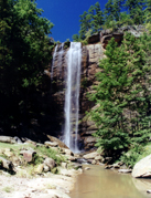 the lower part of the 1,100 acre wooded campus from the base of the 186-foot high waterfall. This majestic waterfall is 29 feet higher than Niagra. Seasonal flowers and conversation benches line the brief path to the falls. "Toccoah" in the Cherokee Indian language means "beautiful". There are five walks around downtown Toccoa, varying from 1 mile to 4.5 miles. The paths are marked with hearts.